
Selecting a Pedestal for Tracking LEO Satellites at Ka Band
Keith Willey
University of Technology, Sydney (UTS), Cooperative Research Centre for Satellite Systems
Sydney, Australia
This article discusses the issues involved in selecting a pedestal for tracking low earth orbit (LEO) satellites. LEO satellites offer several advantages over their geostationary earth orbit (GEO) cousins. Compared to a GEO, a LEO satellite has lower launch costs, reduced power requirements and a significantly reduced roundtrip transmission delay. While a constellation of GEOs can only see earth stations with latitudes less than 81°, the use of polar orbits allows a LEO constellation to communicate with all points on the globe.1 The disadvantages of a LEO satellite are that the earth station must spatially track the satellite across the sky and compensate for Doppler frequencies that are quite large.
The popularity of LEO satellites is increasing rapidly. The advent of constellations such as Iridium (66 satellites), Teledesic (228 satellites), Skybridge (80 satellites) and Globalstar (48 satellites) suggests that LEO constellations could become the basis of future two-way wireless communications systems. This possibility makes the tracking of LEO satellites an important issue for today’s earth station designer. Of the systems discussed here both Iridium and Teledesic use Ka-band links in some form.
The tracking of LEO satellites at Ka band provides new challenges in designing and manufacturing earth stations. The high frequencies of the Ka band mean even a medium-sized antenna produces a narrow beamwidth, resulting in stringent antenna pointing requirements. For example, a 1.2 m parabolic antenna has a 3 dB beamwidth of 0.58° at 30 GHz and 0.88° at 20 GHz. The combination of the uplink and downlink beamwidths requires a pointing accuracy on the order of 0.3° to minimize attenuation caused by pointing errors.
Only the fastest and most expensive azimuth-elevation pedestals are able to continuously track LEO satellites on high elevation passes. The problem occurs when the satellite approaches and departs from its highest elevation. At this point the pedestal must make high speed azimuth movements in order to track the satellite. Insufficient azimuth speed results in the earth station being unable to track the satellite continuously for passes that exceed a particular maximum elevation.
Several methods have been suggested to overcome this problem, including trajectory optimization where the antenna trajectory is modified to minimize antenna pointing losses on or near zenith passes.2 However, a narrow beamwidth precludes the use of this technique. Other solutions include the use of either an azimuth-elevation-tilt pedestal or an X-Y pedestal. Both of these pedestals allow zenith pass tracking.
Azimuth-elevation Pedestals
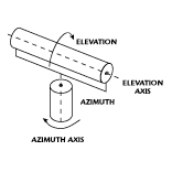 For azimuth-elevation pedestals, the pedestal’s azimuth speed is usually the limiting factor that prevents zenith tracking of a LEO satellite, as shown in Figure 1 . For example, a pedestal with a maximum azimuth velocity of 4°/sec would be unable to continuously track a satellite with a 780 km sun-synchronous orbit (UoSAT-3) for passes with a maximum elevation greater than 82°. In the case of a zenith pass there would be a loss of communications with the satellite for a minimum of 45 seconds. This down time is significant when you consider that during an overhead pass a satellite of this type is only at elevations > 20° for approximately 7.4 minutes.
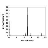
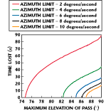 Figure 2 shows the minimum time lost in seconds for passes of a satellite with a 780 km orbit with different maximum elevations for an azimuth-elevation pedestal (which is azimuth limited) with maximum azimuth speeds of 2, 4, 6 and 8°/sec. The situation is even more critical when communication is via a single LEO satellite. In this case, it is not uncommon that during a significant period of time the only usable satellite pass may have a maximum elevation that requires azimuth movements in excess of the earth station’s pedestal capability. This condition occurs because all of the other available passes may have low peak elevation angles. Figure 3 shows an example of this scenario involving passes of a UoSAT-3 satellite over an earth station in May 1998. In an urban environment, Ka-band communications for such passes is almost impossible due to multipathing.3 Even when communication is via a constellation of LEO satellites, these same urban environment restrictions may dictate the use of high elevation satellite passes.
 It is important to utilize these high elevation passes as much as possible because they provide the best signal-to-noise ratio and, hence, allow communication at the highest possible data rates to take place. In addition, the maximum elevation of a particular pass is directly related to the amount of time that the satellite is visible to the earth station. The higher the maximum elevation the longer the satellite is visible.
An additional problem occurs if closed-loop tracking is being used to follow the satellite on a near-zenith pass and the pedestal approaches its velocity limits in either azimuth or elevation. At such a point there is little or no spare capacity left to make off-boresight movements to track the satellite. Thus, the tracking process, should it be required, would have to be suspended until the satellite reached a lower elevation.
Azimuth-elevation-tilt Pedestals
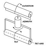 An azimuth-elevation-tilt pedestal, shown in Figure 4 , is an azimuth-elevation pedestal with the addition of a third axis. The tilt axis is perpendicular to the elevation axis. This type of pedestal is sometimes called a three-axis pedestal. At high elevations the elevation and tilt axes are used together to allow full hemispherical tracking of the satellite (including zenith passes); that is, the required elevation-pointing angle is obtained using a combination of the elevation and tilt axes. This capability reduces the elevation axis component of the required pointing angle and, thus, allows sufficient time for the azimuth axis to rotate without exceeding its maximum azimuth drive velocity.4
While the azimuth-elevation-tilt pedestal allows full hemispherical tracking it does have some disadvantages. The addition of the third axis increases the unit’s weight, complexity and manufacturing cost compared to either an X-Y or azimuth-elevation pedestal. In addition, the interaction of the elevation and tilt axes increases the complexity of the required control electronics. Premission orbit determination is required to predict whether the tilt axis will be needed to allow the satellite to be tracked for the entire pass.5 In addition, prepositioning the tilt axis prior to a pass increases the setup time.5 This increase may become significant if an earth station is being used to sequentially track more than one satellite.
X-Y Pedestals
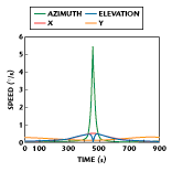
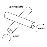 As shown in Figure 5 , an X-Y pedestal has two orthogonal axes: the first is a horizontal fixed primary axis; the second is perpendicular to and mounted on top of the first axis.4 This configuration allows the pedestal to provide zenith pass tracking even with the use of relatively low speed motors. Figure 6 shows the pedestal velocity requirements for an 84° elevation pass of a satellite with a 780 km sun-synchronous orbit over Sydney for both the X-Y and azimuth-elevation cases. An X-Y pedestal design offers several advantages over its azimuth-elevation-tilt and azimuth-elevation counterparts.
 For an X-Y pedestal design the required angular velocities of both axes remain within a small range for all but the lowest elevation satellite passes. This condition is not the case for an azimuth-elevation pedestal where the required angular velocity in azimuth increases rapidly as the maximum elevation of a satellite pass approaches 90°. For an overhead pass of a LEO satellite with an 800 km orbit, the maximum angular velocity required by either axis is only a fraction of a degree per second. This low velocity produces improved pointing accuracy5 compared to the three-axis system where the angular velocity required is significantly higher. Another advantage is that the X and Y axes are identical, which means that the required spare parts can be kept to a minimum.6 In addition, the pedestal can be built from high quality, off-the-self components, which allow economical designs to be constructed6 for a wide range of operating conditions and antenna sizes. Off-the-self components also mean low cost maintenance. The X-Y pedestal uses brushless DC motors, which eliminate the need for expensive rotary joints and slip rings.6 Finally, the X-Y pedestal is a low cost solution where the simplicity of the design compared to a three-axis pedestal increases the mean time between failures (MTBF).5
A standard PC can be used to control the X-Y pedestal, allowing software adjustment of parameters such as tracking speed and tracking range to be set by the user. Two resolvers (one mounted on the shaft of each of the two motors) provide feedback on the antenna pointing angles. Note that an X-Y pedestal is still not capable of full hemispherical tracking but, unlike the azimuth-elevation pedestal that is unable to continuously track high elevation passes, the X-Y pedestal has its limitations at low elevation angles (< 2°) around 90° and 270° in azimuth. At these elevations the satellite moves slowly with respect to the earth station and even small capacity motors (6°/sec) are sufficient to minimize the tracking loss. In any event, it is difficult to imagine a practical application in which such low elevation passes would be required.
Conclusion
Azimuth-elevation pedestals, with the exception of the fastest and most expensive, are unable to continuously track LEO satellites on high elevation passes. This drawback results in loss of communications with the satellite at high elevations, which is the time when the signal should have its highest signal-to-noise ratio. It also causes reduced capacity to perform closed-loop tracking at higher elevation and creates the possibility of having only limited ability to communicate with LEO satellites, especially when the earth station is located in an urban environment.
While an azimuth-elevation-tilt pedestal allows full hemispherical tracking, the addition of the third axis increases its manufacturing cost and the complexity of the required control electronics. The least expensive and most elegant solution to this problem is to use an X-Y pedestal. An X-Y pedestal allows zenith pass tracking even with relatively low speed motors. Additional advantages of an X-Y design include identical X and Y axes, which keep spare part requirements to a minimum,6 and the ability to use high quality, off-the-self components, which allow significant savings.6 In addition, the use of brushless DC motors eliminates the need for expensive rotary joints and slip rings.6 The X-Y pedestal provides improved tracking accuracy for overhead passes compared to three-axis pedestals,5 and offers an improved MTBF compared to other pedestals.5
Acknowledgment
The author would like to thank Michael Eckert, UTS, who edited this article; Ray Clout, UTS, for his input; Ken Bone, Darius Ltd., for his comments regarding the limitations of X-Y pedestals; and Irene Stephens, Australian Broadcasting Corp., and Andrew Thoms, UTS, who created the drawings of the different pedestal types. While the pedestal design and construction are the result of input from several people on the project, Ray Clout performed the majority of the work. The project leader at UTS is Sam Reisenfeld. This work was carried out with financial support from the Commonwealth of Australia through the Cooperative Research Centres program. The UoSAT-3 satellite was built by SURREY Space Centre and launched on January 22, 1990. It has a 780 km sun-synchronous orbit at an inclination of 98°.
References
1. T.S. Kelso, “Basics of the Geostationary Orbit,” Satellite Times , May 1998.
2. P.S. Crawford, “Trajectory Optimization to Minimize Antenna Pointing Error,” Computing and Control Engineering Journal , April 1995.
3. H. Wakana, “Fade Characteristics for K-band Land-mobile Satellite Channels in Tokyo Measured Using COMETS,” Electronics Letters , Vol. 35, No.22, October 1999, pp. 1912-1913.
4. G. Maral and M. Bousquet, Satellite Communications Systems , Third Edition, Wiley, 1998.
5. C. Busch, P. Lancaster and E. Payne, “A Mobile 4.3 Metre Remote Sensing Ground Station Rapid Deployment and High Performance,” International Telemetering Conference Proceedings (33) , October 27-30, 1997.
6. DARIUS, Darius Tracking Pedestal (DTP), www.darius.co.uk/products/antenna/index.htm.
Keith Willey worked for 20 years in the television broadcast industry before receiving his BSEE from the University of Technology, Sydney (UTS) in 1997. As part of his PhD research, he joined the faculty of engineering at UTS’ Cooperative Research Centre for Satellite Systems. Willey’s research interests include the spatial acquisition and tracking of LEO satellites operating at Ka band. He is involved in the design of the Ka-band earth station being built by UTS.