
Orbital Micro Systems (OMS) has released images of Typhoon Hagibis, taken with a 118 GHz, 8-channel microwave radiometer on its IOD-1 GEMS satellite.
"The GEMS 118 GHz, 8 channel microwave radiometer has delivered exceptional spatial resolution and sensitivity in providing imagery and sounding data from Typhoon Hagibis, competitive with multi-billion-dollar government programs performing similar measurements,” said Michael Hurowitz, CTO for OMS. “These images validate the capability of OMS’ remote sensing technology and have demonstrated the highest spatial resolution of any passive microwave temperature sounder flown in space on an operational mission.”
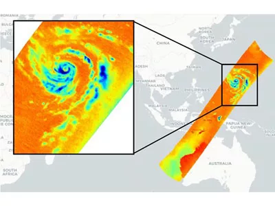
The data from the IOD-1 satellite showed Typhoon Hagibis strengthening dramatically, representing the greatest intensification of a Western Pacific storm since Typhoon Yates in 1996. OMS captured observations of the storm on October 8, 2019 at 12:36 a.m. UTC, shortly after the typhoon intensified from a 60 mph tropical storm to a 150 mph super typhoon, in 18 hours.
The data showed the beginning of the eyewall replacement cycle, a process that occurs with particularly strong storms. During the scan, a core of warmer air — depicted as darker red colors on the right side of the storm — was being drawn into the center of the storm. This warmer air represents a temporary weakening of the storm as a prelude to the development of a new eyewall and further strengthening.
“Observed data from this satellite can be combined with information from government-owned systems to improve the accuracy of storm forecasts,” said Hurowitz. “We are working with other providers and partners to provide enhanced weather information that improves safety margins for people and businesses facing severe weather events.”
The raw data downlinked from the satellite was processed at OMS’s International Centre for Earth Data (ICED) located in Edinburgh, Scotland.