

Satellites are integral to modern life, profoundly impacting various domains and enhancing our daily experiences. Satellites form the backbone of the Global Positioning System (GPS). Weather forecasting relies heavily on satellite data to monitor atmospheric conditions, and with new satellite constellations like Starlink, satellites play a pivotal role in telecommunications. Additionally, satellites contribute significantly to scientific research by observing Earth’s climate, tracking environmental changes, and exploring outer space. Their role in national security and surveillance also ensures geopolitical stability. Overall, satellites are indispensable in connecting the world, enhancing safety, and expanding our understanding of the universe.
For scientists and engineers working on satellites, the initial step in designing a satellite communication link is to establish satellite constellations, their orbits, and perform access and link analyses. These tasks fall under the broader scope of Satellite Scenario Modeling, a critical process that ensures efficient and reliable satellite links. By accurately modeling these scenarios, engineers can optimize satellite operations, enhance communication capabilities, and effectively plan for various mission requirements.
To appreciate the significance of Satellite Scenario Modeling, consider the real-world application of tracking aircraft via satellites. When an aircraft flies over ocean, it often loses direct line of sight with ground-based surveillance and tracking stations due to the Earth's curvature. In such scenarios, satellite-based systems become essential, enabling continuous tracking of the aircraft. These systems ensure that real-time information about the aircraft's position, speed, and trajectory is consistently available to other aircraft and airports, regardless of their proximity to land-based infrastructure.
3-Step Satellite Scenario Modeling Workflow for tracking aircraft
Aircrafts communicate their identities, positions, and velocities using Automatic Dependent Surveillance–Broadcast (ADS-B) Out or ADS-B Out systems that can connect to a variety of targets including airports and the Iridium NEXT satellite constellation. To analyze this scenario in software, engineers can do the following:
- Create the scenario containing an aircraft, airports or ground stations and Iridium satellite network.
- Perform access analysis to determine when the aircraft has line-of-sight access with the airports or satellites within the Iridium network.
- Perform link closure analysis of the ADS-B Out system with the airports and the satellites.
Step 1: Create the scenario containing an aircraft, airports, and Iridium satellite network
First, we define the positions of two airports using their latitude and longitude coordinates, adding them to the scenario. Next, we create the aircraft's trajectory by specifying its initial and final locations, and its altitude and orientation along the path. The aircraft is then added to the scenario and set to follow the defined trajectory. In our scenario, we have selected a flight from JFK International Airport in New York to L.F. Wade International Airport in Bermuda, as illustrated in Figure 1. The modeled aircraft is depicted in Figure 2. Finally, we incorporate the active Iridium NEXT satellites into the scenario. Launched between 2018 and 2019, the Iridium NEXT satellite network comprises 66 active LEO satellites’ the constellation is shown in Figure 3.
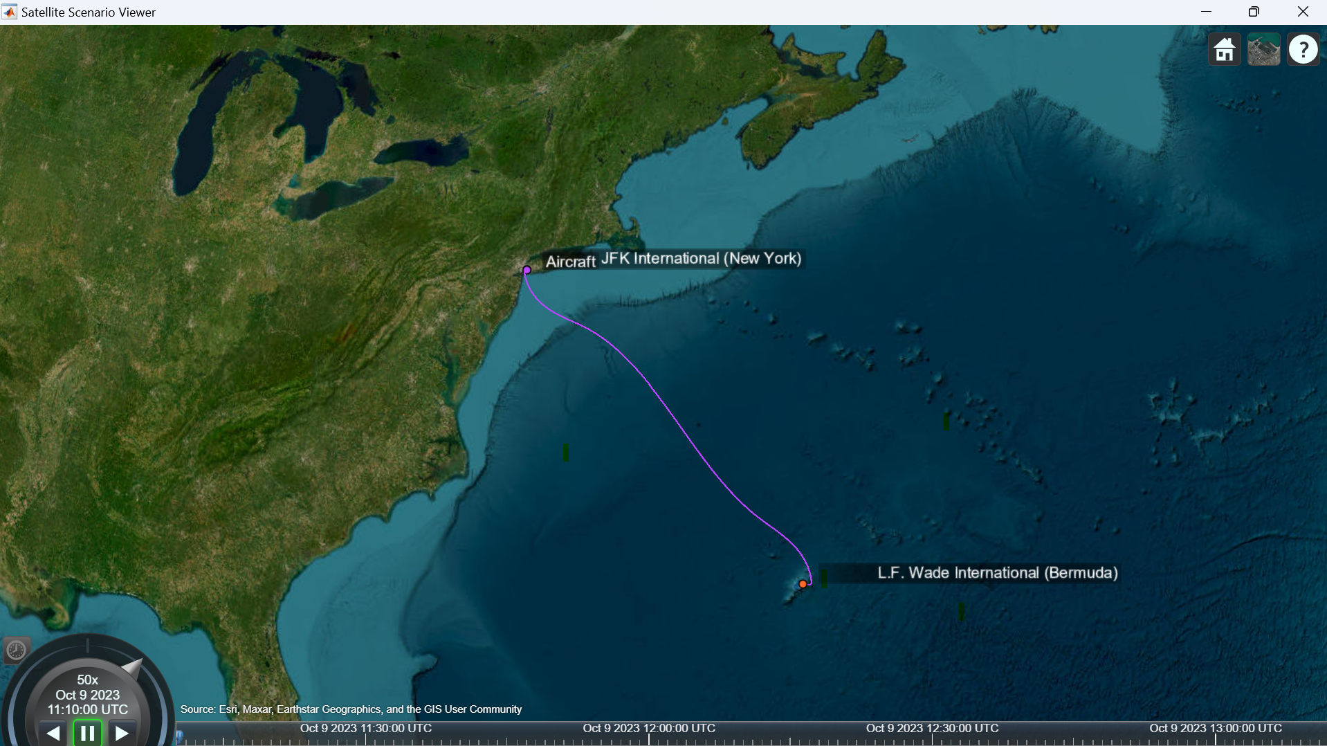
Figure 1: Flight trajectories from the source to the destination, ©2025 The MathWorks, Inc
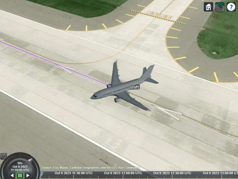
Figure 2: Model of Aircraft used in this Satellite Scenario. ©2025 The MathWorks, Inc
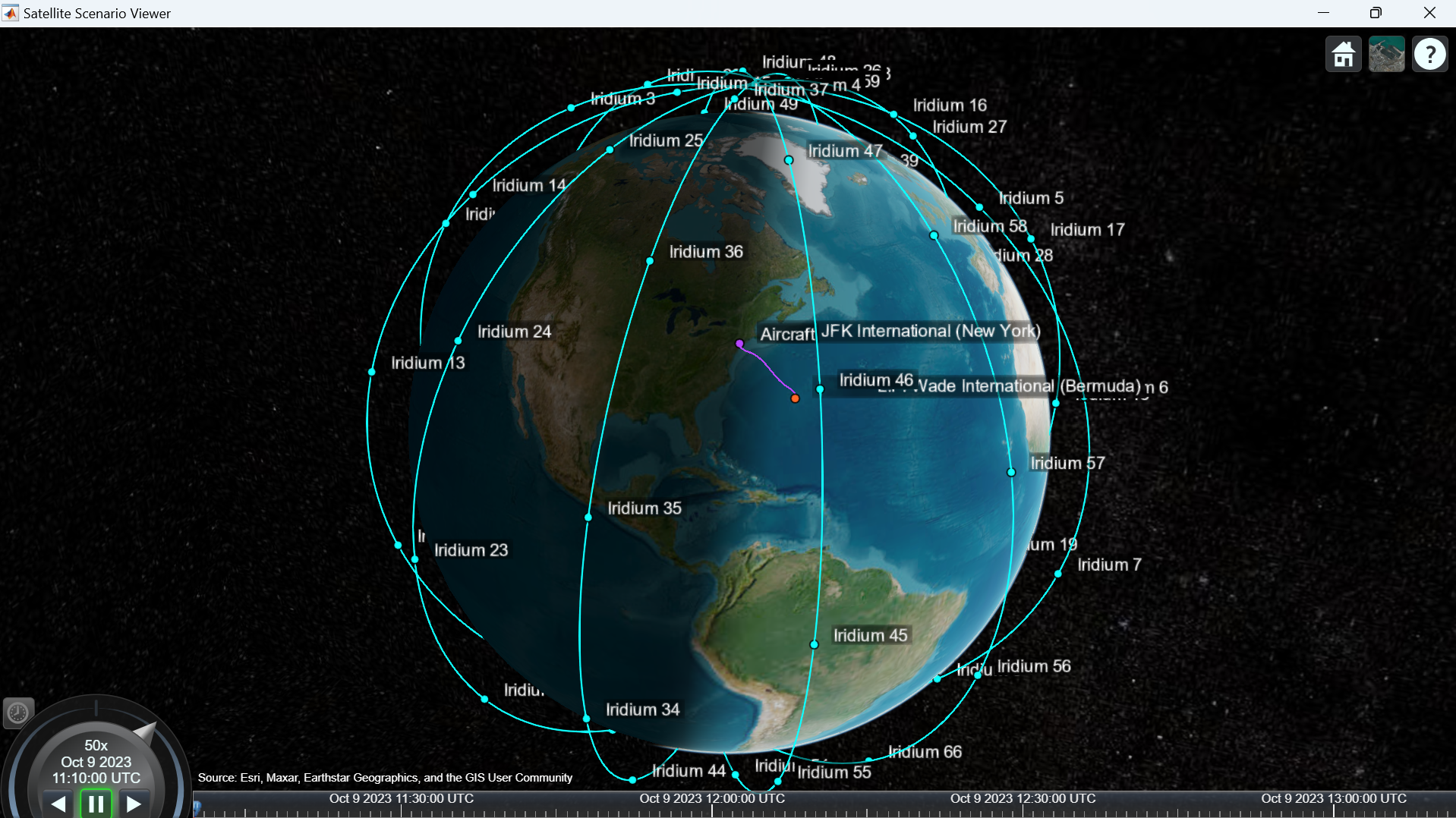
Figure 3: Iridium NEXT satellite constellation. ©2025 The MathWorks, Inc
Step 2: Perform access analysis to determine when the aircraft has line-of-sight access with the satellites within the Iridium network
Access analysis, or visibility access analysis, involves determining the time intervals during which a satellite can maintain a line of sight with a platform, which, in our application, is an aircraft. This analysis is conducted between the aircraft and the Iridium NEXT constellation and plot the results. The access analysis findings are presented in Figure 4. Our analysis reveals that the aircraft maintains continuous access to the Iridium network throughout the entire flight duration. The simplest way to interpret the plot is to draw a vertical line at any given moment during the simulation; observe that at least one satellite is always in view of the aircraft. This ensures uninterrupted tracking and communication, highlighting the effectiveness of the satellite network in providing reliable coverage even over remote areas.
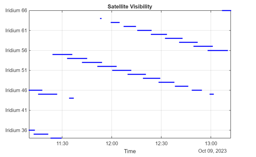
Figure 4 Access analysis between aircraft and Iridium NEXT constellation. ©2025 The MathWorks, Inc
Step- 3 Perform link closure analysis of the ADS-B Out system with the airports and the satellites
A link analysis was performed between the aircraft and airports to identify the specific times when the satellite can effectively communicate with the aircraft throughout the day. To achieve this, the aircraft is equipped with a transmitter configured to ADS-B (Automatic Dependent Surveillance-Broadcast) standards, along with an antenna. At the airports, isotropic antennas and receivers are attached to ensure consistent signal reception. Additionally, link analysis was carried out between the aircraft and Iridium satellites. Each satellite in the Iridium constellation is attached with a receiver and a custom 48 spot beam antenna which is deployed on the Iridium NEXT satellites orbiting the earth.
In this scenario, there is one transmitter on the aircraft and a total of 68 receivers—66 on the satellites and two at the airports. The maximum link margin was plotted throughout the flight as shown in Figure 5. Initially, the margin decreases by 20*log10 of the distance from the aircraft to JFK Airport. When the aircraft loses direct visibility with JFK, the margin drops significantly due to the increased path loss associated with communicating via satellites. As the aircraft relies on satellites as relays, the margin fluctuates as different satellites enter and exit its view. Once the aircraft regains visibility with LF Wade, the margin improves dramatically and then continues to increase by 20*log10 of the distance from the aircraft to LF Wade.
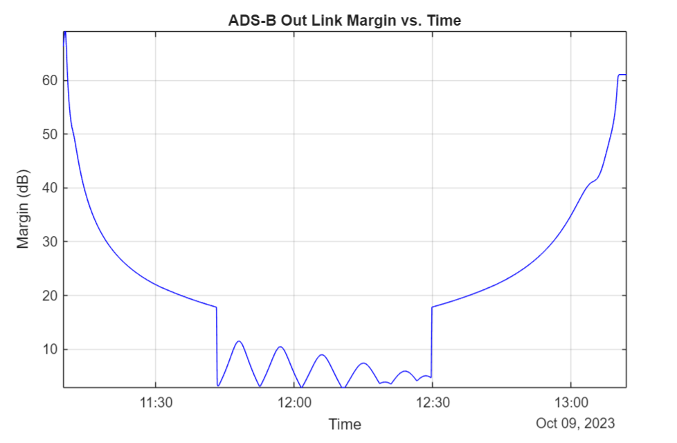
Figure 5 Maximum link margin for the link to any of the available receivers. ©2025 The MathWorks, Inc
Results and Conclusion
The Figure 6 illustrates the results of satellite scenario modeling for the aircraft tracking application. It presents the same scenario from two different frames of reference: the left visual is from the perspective of the satellites, while the right visual is from the perspective of the aircraft. In the animation, the dotted green line indicates visual access, whereas the solid green line signifies link closure between the satellites and aircraft. The aircraft's trajectory is depicted by a purple line. Additionally, the animation showcases the antenna beam pattern of the custom 48-beam antenna used by the Iridium NEXT satellites, highlighting their capability to maintain robust communication links throughout the flight. This dual-perspective visualization provides a comprehensive understanding of the interaction between the aircraft and satellite network.

Figure 6 Visualization of aircraft tracking application. ©2025 The MathWorks, Inc.
In summary, satellite scenario modeling is critical in the design and optimization of satellite-based systems, offering profound insights into the dynamics of satellite interactions with various platforms, such as aircraft. By simulating scenarios, engineers and scientists can predict and analyze the performance of satellite constellations, ensuring reliable communication and data transmission across diverse environments. This modeling enables the identification of optimal configurations and strategies for maintaining continuous coverage, even in challenging conditions like remote or oceanic regions. Furthermore, it aids in the efficient allocation of resources, such as frequency bands and power, enhancing overall system performance and cost-effectiveness. Ultimately, satellite scenario modeling is crucial for advancing satellite technology and ensuring the robustness of global communication networks, navigation systems, and Earth observation missions.
To learn more about the topics covered in this Code & Waves blog and explore such designs, see the examples below or email vijayenk@mathworks.com for more information.
- Aircraft-to-Satellite Communication for ADS-B Out (Example code): Learn how to implement the satellite scenario for aircraft tracking.
- Iridium Satellite Spot Beam Coverage on the US (Example Code): Learn how to generate and visualize Iridium satellite spot beams on the U.S. map.
- Interference from Satellite Constellation on Communications Link (Example code): Learn how to analyze interference on a downlink from a constellation of Low-Earth Orbit (LEO) satellites in a Medium-Earth Orbit (MEO) to a ground station.
- Analyze NTN Coverage and Capacity for LEO Mega-Constellation (Example code): Learn how to analyze coverage and capacity of a very low population density region for LEO mega-constellation for satellite-based NTN applications.
- Satellite Communications Toolbox (Web Page): Simulate, analyze, and test satellite communications systems and links.