

In cases where NLOS conditions are more severe, Facebook uses low-cost drone technology, developed with Plexus Controls in Ottawa, to measure the path loss as part of pre-build field survey and path confirmation (see Figure 3). Figure 4 illustrates how signal level measurements using drones can map path losses throughout a 3D volume to determine the optimum location for a tower and its height.
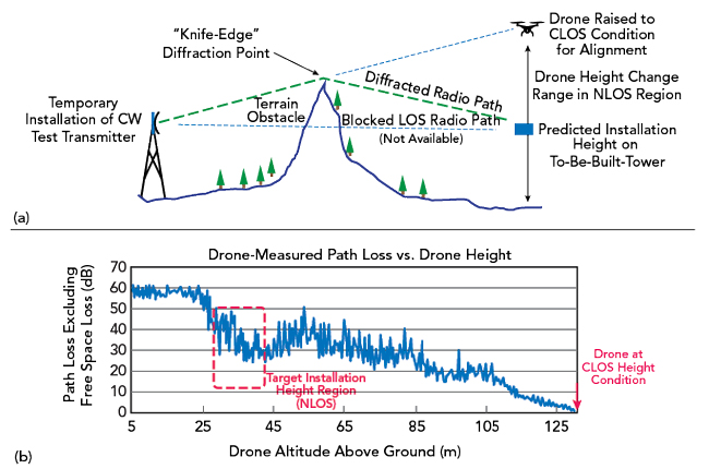
Figure 4 Using a drone for pre-build field verifications of NLOS links (a) and example path loss measurement (b).
NETWORK DESIGN COMBINING CLOS AND NLOS
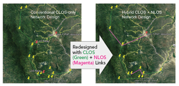
Figure 5 Optimizing a backhaul network combining CLOS and NLOS radio links.
The combination of CLOS and NLOS to optimize microwave backhaul networks has been previously reported,10 illustrating the utility of this combination of techniques in creating improved rural and deep-rural connectivity and simultaneously reducing costs (see Figure 5). In other cases, reaching a remote cluster of settlements can be impeded by challenging terrain between a developed part of the network and a target coverage area where new radio access network deployments are required. The example illustrated in Figure 6 shows a targeted area for delivering coverage to a cluster of dispersed rural/deep-rural settlements. CLOS backhaul radio links within the cluster may be feasible, but the cluster itself cannot be reached easily or cost-effectively using terrestrial CLOS backhaul links.
In larger scale deployments, Facebook has partnered with Internet para Todos (IpT) in Peru to deploy 4G networks in large segments of the unserved and underserved population in rural and deep-rural Peru. In one phase of network buildout, the hybrid combination of CLOS and NLOS has achieved a significant improvement in the network’s coverage. When this article was written, IpT had incorporated diffractive NLOS microwave backhaul links in its network by deploying 28 diffractive NLOS links in the production network. These links provide both backbone and end-point connectivity. The hybrid use of NLOS and CLOS wireless backhaul in the network redesign yields a substantial increase in the network’s coverage and cost performance. Further, the hybrid network enables IpT network designers to efficiently expand the terrestrial network without modifying the infrastructure, which would be necessary if only CLOS links were used.
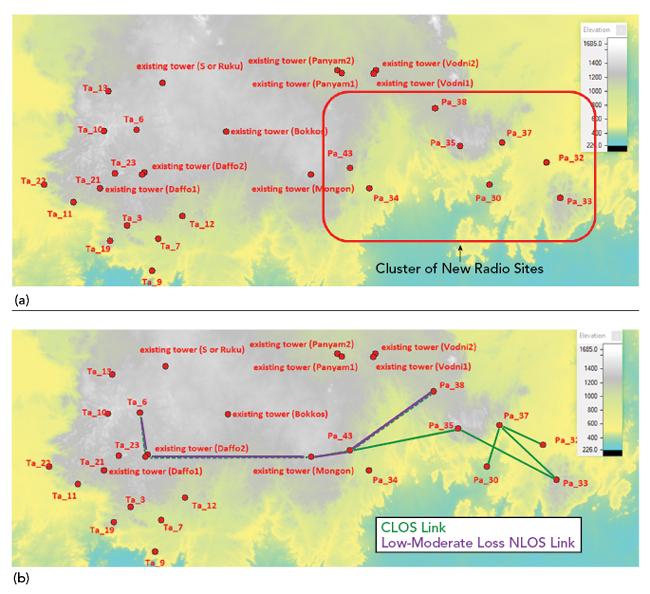
Figure 6 A rural/deep-rural area with a cluster of new radio sites (a); most can be connected to the existing network using a combination of CLOS and low-to-moderate loss NLOS links.
In many target settlements, terrain and foliage obstacles make CLOS links unfeasible. Without NLOS, this means those settlements would be served with satellite backhaul. With NLOS, IpT has been able to provide wireless broadband coverage via NLOS microwave backhaul, an option available to other service providers.
SUMMARY
Solving rural and deep-rural connectivity challenges in a cost-effective manner requires the application of various technologies and techniques. High capacity mobile radio networks can be backhauled using terrestrial microwave systems; however, using only CLOS links can be impractical. The hybrid combination of CLOS and NLOS techniques can often be employed to create a practical, lower-cost networking solution.
ACKNOWLEDGMENTS
We thank our partners at IpT de Peru: Renan Ruiz Moreno, Joel Aragon Valladares and Manuel Garcia Lopez. We also thank our partners at TeleworX: José Huarcaya and Diego Mendoza. Their work on the development and implementation of NLOS has been critical to the success of this endeavor.
References
- “Global Mobile Trends: What’s Driving the Mobile Industry?” GSMA Intelligence, September 2018.
- “GSMA – Backhaul for Mobile Networks,” ABI Research, September 2018.
- R.L. Freeman, Radio System Design for Telecommunications, Wiley-InterScience, 2007.
- A. G. Longley and P. L. Rice, Prediction of Tropospheric Radio Transmission Loss Over Irregular Terrain. A Computer Method, NTIS, 1968.
- P.526 : Propagation by Diffraction, International Telecommunications Union, Web, www.itu.int/rec/R-REC-P.526/en.
- P.530 : Propagation Data and Prediction Methods Required for the Design of Terrestrial Line-of-Sight Systems, International Telecommunications Union, P.530-8/13, Web, www.itu.int/rec/R-REC-P.530/en.
- Terrain Integrated Rough Earth Model (TIREM) Software, Alion Science and Technology, Web, www.alionscience.com/terrain-integrated-rough-earth-model-tirem/.
- PathLoss 5.0 software, Telecommunication Engineering, Web, www.pathloss.com/.
- P.530 : Propagation Data and Prediction Methods Required for the Design of Terrestrial Line-of-Sight Systems, International Telecommunications Union, P.530 series, Web, www.itu.int/rec/R-REC-P.530/en.
- J. Kusuma and E. Boch, “Improving Rural Connectivity Coverage Using Diffractive Non-Line-of-Sight (NLOS) Wireless Backhaul,” World Wireless Research Forum, January 2021.