
As a satellite orbits the Earth, it will lose line-of-site to the gateways. To maintain a call or data connection, the constellation has the intelligence to forward the routing tables and frames to the next satellite coming into view of the gateway. Tracing the path of a call between Iridium users, a call from a satellite phone goes to one of the satellites in view, and the call is either sent directly to the receiving user or, if the receiver is not in one of the spot beams of the satellite receiving the call, the call is routed from satellite to satellite via the K-Band intersatellite links until it reaches the satellite covering the receiver. If a call from a satellite phone connects to the PSTN, the satellite phone links to one of the satellites in view, and the call is either sent directly to the GES via the downlink or, if the gateway is not in view of the satellite, the call is routed from satellite to satellite via the K-Band ISL until it reaches a satellite in view of the GES, then sent via the downlink to connect to the PSTN or other terrestrial network.
USER SEGMENT
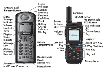
Figure 6 Motorola (left) and Iridium (right) handheld satellite phones.
The Iridium NEXT satellite network offers voice, data and video services for maritime, land and aeronautical applications, offering users both mobile and semi-fixed equipment (see Figures 1 and 5). The equipment is classified by the platform or use case, such as a ship earth station, vehicle earth station, aircraft earth station or personal earth station. User terminals with omnidirectional antennas support numeric and alphanumeric paging and data and facsimile transmission at 2.4 kbps. All voice and messaging services are delivered regardless of the user’s location or the availability of PSTN access. Equally important, Iridium offers tracking and location services for maritime, land (road and rails), aeronautical and personal applications.8
Like cellular phones, Iridium handheld or portable telephones are used for voice and text messaging, and their dimensions, weight and battery lifetime are like those of cellular phones.9 For example, the Motorola 9505 handheld (see Figure 6a) is small, light and water-resistant, making it well-suited for industrial and rugged environments, yet appealing to a traveling professional. The phone has 3.2 hours talk time and 30 hours standby time. The handset can be docked for hands-free calls and to charge the battery.
Iridium’s own Extreme 9575 mobile handles voice, data, SMS and is the only Iridium phone with integrated GPS tracking (see Figure 6b). The GPS capability enables viewing and sending GPS satellite position as an SMS message to another device or to the StratosTrax tracking portal using short burst data (SBD). A certified Satellite Emergency Notification Device (SEND), the phone provides a one-touch SOS for distress calls, requesting help in an emergency and notifying the user when help is on the way. The phone includes Wi-Fi and can create a Wi-Fi hotspot, using Iridium to connect to the internet.
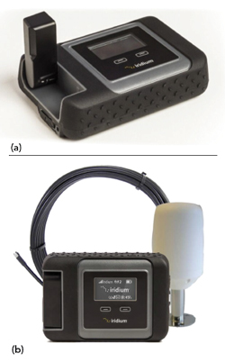
Figure 7 Iridium GO! with internal (a) and external (b) helix antenna.

Figure 8 Iridium SHOUT Nano handheld, two-way messaging and personal tracking device.
Iridium GO! is a flexible, multipurpose satellite transceiver that includes a Wi-Fi link, so users can connect their smartphones, tablets or laptops for voice and data communications. It has a built-in antenna, which is sufficient for personal use (see Figure 7a). To improve signal levels in fixed installations, external antennas can be used: helix antennas are available for mounting on a ship or the roof of a building (see Figure 7b) and flat, magnetic-mount antennas are used for vehicles.10
SATELLITE TRACKERS
Satellite tracking is an important service for shipping and logistics as well as personal safety. In areas with no cellular coverage, Iridium provides an alternative enabling continuous monitoring. The Quake Q4000 is one example of a product developed for shipping and logistics. It’s a rugged two-way modem that combines GPS with either Iridium or GSM to provide a mobile asset tracking solution using a web-based online application. The Q4000 provides PVT data including altitude, transmitted as SBD through Iridium to the cloud.11
Handheld personal satellite trackers are used for personal safety. They have the same functionality as an industrial tracker: a GPS receiver to determine location and a satellite transceiver to relay location and messaging through the satellite network. However, personal trackers must be light weight and battery powered, with long battery life. The SHOUT Nano shown in Figure 8 is an example of a tracker used with the Iridium network. Handheld, it provides two-way messaging and location tracking, using SBD to send GPS location, text messaging and emergency notification. The SHOUT Nano has an internal 1.95 A h rechargeable lithium-ion battery, is 4.0 × 2.2 × 0.8 in. in size and weighs 6.5 oz.12
CONCLUSION
After a bold yet inauspicious start, Iridium has become the largest and longest running commercial satellite communications system fully in operation and the only network that offers global coverage. The current generation constellation, Iridium NEXT, provides voice, data and video services for users on land, sea and air.
But that’s not the end of the story. As data rates have surged on terrestrial networks, a new set of satellite networks—OneWeb, Starlink, Project Kuiper, Telesat Lightspeed perhaps the best known—are being developed to bring terrestrial broadband speeds to users in remote areas. They are enabled by low launch costs, highly integrated RF and digital processing and billions of dollars from entrepreneurs. As exciting as the applications, the orbital physics and engineering of satellite communications systems are equally interesting. Curious readers will find a library of resources to learn more about the principles behind these systems.13-17
References
- Iridium, “The Concept for the Iridium Global Constellation Is Born,” Iridium Museum, Web: www.iridiummuseum.com/timeline.
- C. Mellow, “The Rise and Fall and Rise of Iridium,” Air & Space Magazine, September 2004, Web: www.airspacemag.com/space/the-rise-and-fall-and-rise-of-iridium-5615034/.
- Iridium, “Development of the Iridium NEXT Satellite System,” 2021.
- Iridium, “Manual for Iridium Satellite Communications Service,” 2008.
- Apollo Satellite Communications, “Iridium Satellite System Operation,” June 1, 2016, Web: apollosat.com/iridium-satellite-frequency-bands.
- Iridium, “Architecture of Iridium Space, Ground and User Segments,” 2020.
- Iridium, “Iridium Gateway,” 2010.
- D. S. Ilcev, Global Mobile Satellite Communications for Maritime, Land and Aeronautical Applications, Vol. 2, 2017.
- Iridium, “Satellite Phones,” Web: www.iridium.com/product-type/satellite-phones.
- Iridium, Iridium GO!, Web: www.iridium.com/products/iridium-go.
- Quake Global, Q4000 Multi-network communication device, Web: www.quakeglobal.com/products/q4000.
- Iridium, SHOUT Nano Pocket-Sized, Self-Contained Satellite Tracker, Web: www.iridium.com/products/nal-research-shout-nano-personnel-tracker.
- CNS Systems, Mobile Satellite Communication Systems, Durban, South Africa, 2019.
- A. Jamalipour, Low Earth Orbit Satellites (LEO) for Personal Communication Networks, 1998.
- ITU, “Handbook on Satellite Communications,” ITU, 2003.
- R.E. Sheriff et al., Mobile Satellite Communication Networks, 2001.
- M. Ilcev et al., “Introduction to the Global Ship Tracking System via Mobile Satellite Constellations,” The 1st International Conference on Maritime Education and Development (DUT), Conference Proceedings Book, 2021.